 Electoral Palatinate: All Data
This page is about the data available for this polity; the chronology of its events is available here.
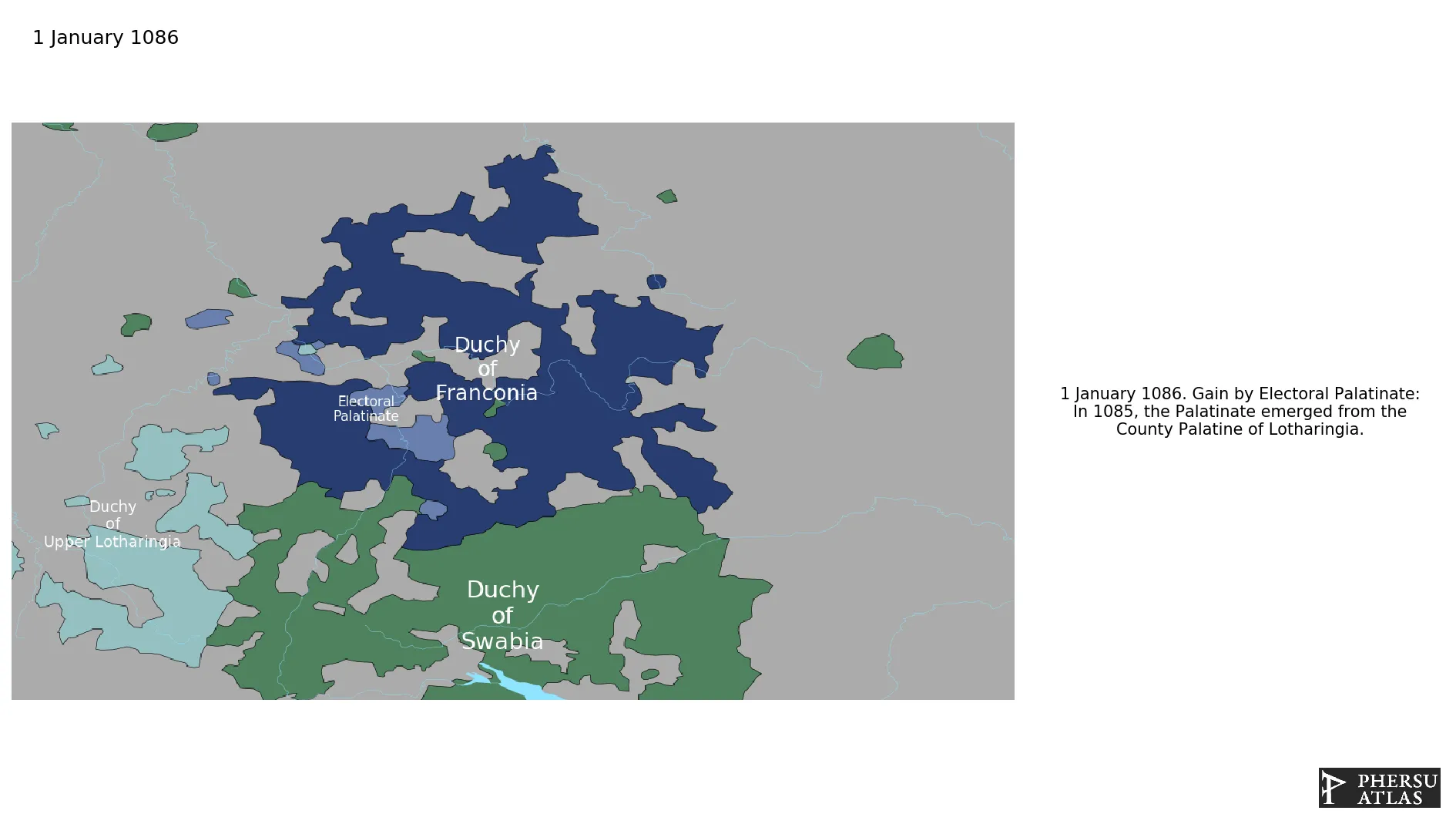
Was a state that was part of the Holy Roman Empire. The electorate had its origins under the rulership of the Counts Palatine of Lotharingia from 915, it was then restructured under the Counts Palatine of the Rhine in 1085. It divided and reunited several times, but only the division of Upper Palatinate is considered effective in the model, as derived from the maps in G. Droysen, “Historischer Handatlas” (1886).
1. Genealogy

2. Maps of Political Control Over Time
 Electoral Palatinate : Map showing the initial year each territory was ruled by the polity
Electoral Palatinate : Maximal Extension of the Polity
Electoral Palatinate : Map showing the initial year each territory was ruled by the polity
Electoral Palatinate : Maximal Extension of the Polity
3. Monthly Summaries

4. Lists and Timelines
5. Rankings
 Electoral Palatinate : Top wars ordered by largest reached area
Electoral Palatinate : Top wars by territorial gain or loss in terms of area of the changes
Electoral Palatinate : Top wars by territorial gain or loss in terms of area difference
Electoral Palatinate : Top wars ordered by largest reached area
Electoral Palatinate : Top wars by territorial gain or loss in terms of area of the changes
Electoral Palatinate : Top wars by territorial gain or loss in terms of area difference
6. Time Series
Electoral Palatinate : Time Series of all Territorial Changes
Electoral Palatinate : time series of its population and area throughout history
7. All Events mentioned in Territorial Changes
 War of the Succession of Landshut
War in Palatinate
Thirty Years' War
War of the Jülich Succession
Franco-Dutch War
Nine Years' War
War of the Spanish Succession
Seven Years' War
War of the Succession of Landshut
War in Palatinate
Thirty Years' War
War of the Jülich Succession
Franco-Dutch War
Nine Years' War
War of the Spanish Succession
Seven Years' War
8. All Cities mentioned in Territorial Changes
 Veldenz
Grumbach
Mosbach
Saverne
Veldenz
Zweibrücken
Grumbach
Sponheim
Stahleck
Kaiserslautern
Zweibrücken
Kaiserslautern
Veldenz
Grumbach
Saverne
Deutz
Veldenz
Zweibrücken
Grumbach
Kaiserslautern
Burick
Philippsburg
Frankenthal
Oppenheim
Worms
Worms
Bingen
Kaiserslautern
Kaiserslautern
Heidelberg
Heidelberg
Speyer
Mainz
Heidelberg
Oppenheim
Bingen
Heidelberg
Düsseldorf
Bergen (Frankfurt)
Düsseldorf
Veldenz
Zweibrücken
Grumbach
Sponheim
Stahleck
Kaiserslautern
Veldenz
Zweibrücken
Grumbach
Sponheim
Stahleck
Kaiserslautern
Veldenz
Zweibrücken
Grumbach
Kaiserslautern
Mannheim
Heidelberg
Kaiserslautern
Mannheim
Mannheim
Heidelberg
Korbach
Grumbach
Grävenstein
Kaiserslautern
Veldenz
Stahleck
Grumbach
Grävenstein
Grumbach
Kufstein
Vohburg an der Donau
Lowenstein
Grävenstein
Veldenz
Zweibrücken
Grumbach
Sponheim
Stahleck
Kaiserslautern
Heidelberg
Mannheim
Heidelberg
Veldenz
Zweibrücken
Grumbach
Sponheim
Stahleck
Kaiserslautern
Philippsburg
Zweibrücken
Kaiserslautern
Bad Mergentheim
Burick
Philippsburg
Philippsburg
Frankenthal
Frankenthal
Heidelberg
Mannheim
Heidelberg
Mannheim
Heidelberg
Kaiserslautern
Landau
Trarbach
Düsseldorf
Düsseldorf
Düsseldorf
Bergen (Frankfurt)
Korbach
Veldenz
Zweibrücken
Grumbach
Sponheim
Stahleck
Kaiserslautern
Oppenheim
Worms
Worms
Bingen
Kaiserslautern
Kaiserslautern
Heidelberg
Heidelberg
Speyer
Mainz
Waldeck (Bavaria)
Lechgemünd
Sulzbach-Rosenberg
Hohenburg
Cham
Lechgemünd
Hohenburg
Cham
Waldeck (Bavaria)
Sulzbach-Rosenberg
Sponheim
Oppenheim
Grävenstein
Mosbach
Landau
Heidelberg
Mannheim
Rheinberg
Mannheim
Mannheim
Landau
Bad Mergentheim
Mannheim
Schorndorf
Düsseldorf
Wuppertal
Jülich
Düren
Zweibrücken
Frankenthal
Lowenstein
Bingen
Mannheim
Mosbach
Düsseldorf
Veldenz
Wuppertal
Zweibrücken
Mannheim
Heidelberg
Jülich
Düren
Grumbach
Sponheim
Stahleck
Kaiserslautern
Mosbach
Braunau am Inn
Kufstein
Mannheim
Mannheim
Veldenz
Grumbach
Mosbach
Saverne
Veldenz
Zweibrücken
Grumbach
Sponheim
Stahleck
Kaiserslautern
Zweibrücken
Kaiserslautern
Veldenz
Grumbach
Saverne
Deutz
Veldenz
Zweibrücken
Grumbach
Kaiserslautern
Burick
Philippsburg
Frankenthal
Oppenheim
Worms
Worms
Bingen
Kaiserslautern
Kaiserslautern
Heidelberg
Heidelberg
Speyer
Mainz
Heidelberg
Oppenheim
Bingen
Heidelberg
Düsseldorf
Bergen (Frankfurt)
Düsseldorf
Veldenz
Zweibrücken
Grumbach
Sponheim
Stahleck
Kaiserslautern
Veldenz
Zweibrücken
Grumbach
Sponheim
Stahleck
Kaiserslautern
Veldenz
Zweibrücken
Grumbach
Kaiserslautern
Mannheim
Heidelberg
Kaiserslautern
Mannheim
Mannheim
Heidelberg
Korbach
Grumbach
Grävenstein
Kaiserslautern
Veldenz
Stahleck
Grumbach
Grävenstein
Grumbach
Kufstein
Vohburg an der Donau
Lowenstein
Grävenstein
Veldenz
Zweibrücken
Grumbach
Sponheim
Stahleck
Kaiserslautern
Heidelberg
Mannheim
Heidelberg
Veldenz
Zweibrücken
Grumbach
Sponheim
Stahleck
Kaiserslautern
Philippsburg
Zweibrücken
Kaiserslautern
Bad Mergentheim
Burick
Philippsburg
Philippsburg
Frankenthal
Frankenthal
Heidelberg
Mannheim
Heidelberg
Mannheim
Heidelberg
Kaiserslautern
Landau
Trarbach
Düsseldorf
Düsseldorf
Düsseldorf
Bergen (Frankfurt)
Korbach
Veldenz
Zweibrücken
Grumbach
Sponheim
Stahleck
Kaiserslautern
Oppenheim
Worms
Worms
Bingen
Kaiserslautern
Kaiserslautern
Heidelberg
Heidelberg
Speyer
Mainz
Waldeck (Bavaria)
Lechgemünd
Sulzbach-Rosenberg
Hohenburg
Cham
Lechgemünd
Hohenburg
Cham
Waldeck (Bavaria)
Sulzbach-Rosenberg
Sponheim
Oppenheim
Grävenstein
Mosbach
Landau
Heidelberg
Mannheim
Rheinberg
Mannheim
Mannheim
Landau
Bad Mergentheim
Mannheim
Schorndorf
Düsseldorf
Wuppertal
Jülich
Düren
Zweibrücken
Frankenthal
Lowenstein
Bingen
Mannheim
Mosbach
Düsseldorf
Veldenz
Wuppertal
Zweibrücken
Mannheim
Heidelberg
Jülich
Düren
Grumbach
Sponheim
Stahleck
Kaiserslautern
Mosbach
Braunau am Inn
Kufstein
Mannheim
Mannheim