 Margraviate of Baden: All Data
This page is about the data available for this polity; the chronology of its events is available here.
Was a historical territory of the Holy Roman Empire located along the east side of the Upper Rhine River in southwestern Germany.
1. Genealogy
2. Maps of Political Control Over Time
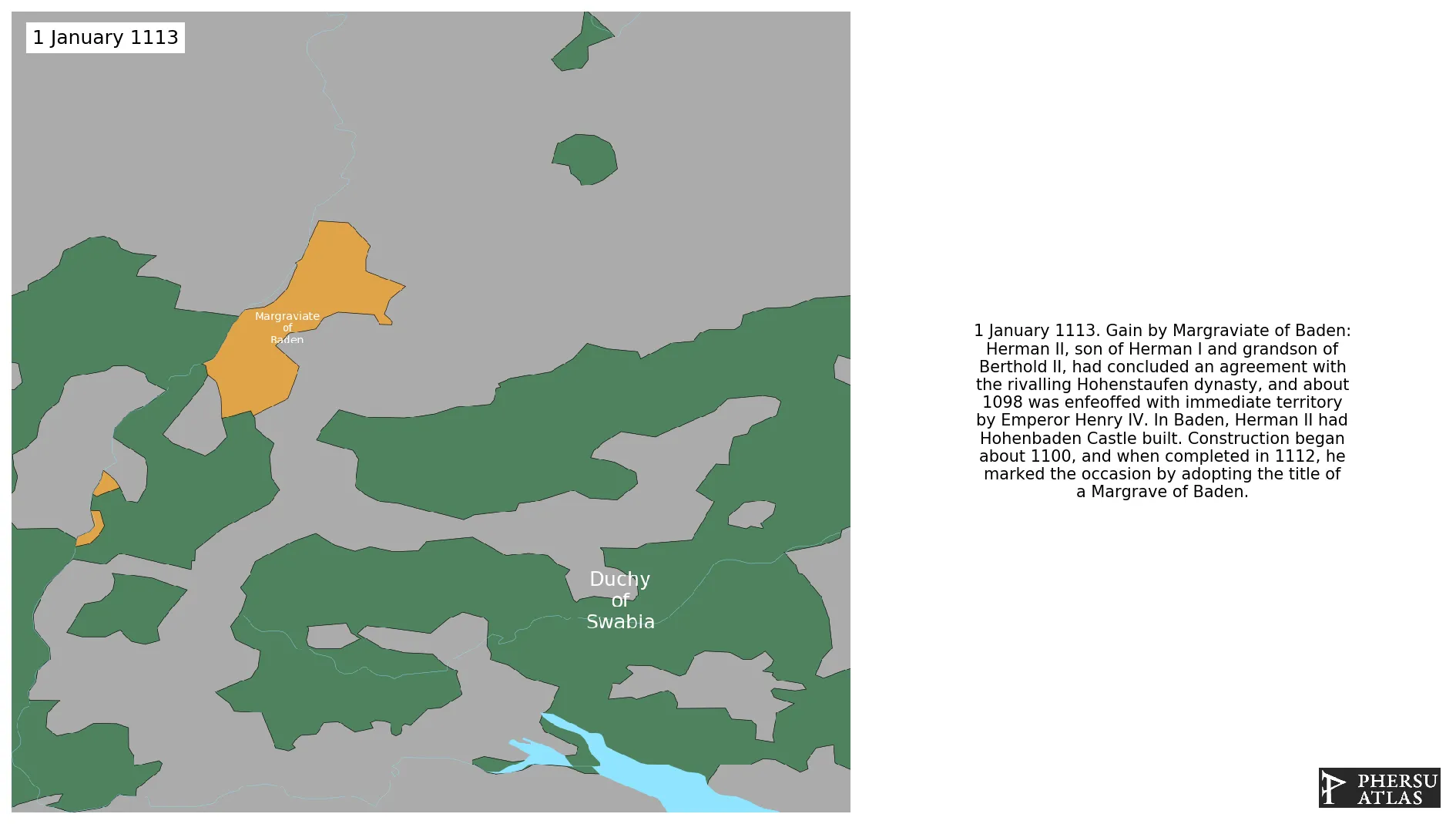
 Margraviate of Baden : Map showing the initial year each territory was ruled by the polity
Margraviate of Baden : Map depicting the polity's ruler in power when each territory was first controlled
Margraviate of Baden : Maximal Extension of the Polity
Margraviate of Baden : Map showing the initial year each territory was ruled by the polity
Margraviate of Baden : Map depicting the polity's ruler in power when each territory was first controlled
Margraviate of Baden : Maximal Extension of the Polity
3. Monthly Summaries

4. Lists and Timelines
 Margraviate of Baden : List of events the polity was involved in
Margraviate of Baden : List of Rulers
Margraviate of Baden : Timeline of Rulers
Margraviate of Baden : List of events the polity was involved in
Margraviate of Baden : List of Rulers
Margraviate of Baden : Timeline of Rulers
5. Rankings
 Margraviate of Baden : Top rulers ordered by largest reached area
Margraviate of Baden : Top wars ordered by largest reached area
Margraviate of Baden : Top rulers by territorial gain or loss in terms of area difference
Margraviate of Baden : Top wars by territorial gain or loss in terms of area of the changes
Margraviate of Baden : Top wars by territorial gain or loss in terms of area difference
Margraviate of Baden : Top rulers ordered by largest reached area
Margraviate of Baden : Top wars ordered by largest reached area
Margraviate of Baden : Top rulers by territorial gain or loss in terms of area difference
Margraviate of Baden : Top wars by territorial gain or loss in terms of area of the changes
Margraviate of Baden : Top wars by territorial gain or loss in terms of area difference
6. Time Series
Margraviate of Baden : Time Series of all Territorial Changes
Margraviate of Baden : time series of its population and area throughout history
7. All Events mentioned in Territorial Changes
 Thirty Years' War
Franco-Dutch War
Nine Years' War
War of the Spanish Succession
War of the Polish Succession
War of the Austrian Succession
War of the First Coalition
War of the Second Coalition
Thirty Years' War
Franco-Dutch War
Nine Years' War
War of the Spanish Succession
War of the Polish Succession
War of the Austrian Succession
War of the First Coalition
War of the Second Coalition
8. All Cities mentioned in Territorial Changes
 Kehl
Grävenstein
Laufenburg
Freiburg im Breisgau
Freiburg im Breisgau
Baden
Sausenburg
Grävenstein
Kehl
Grävenstein
Speyer
Karlsruhe
Baden
Freiburg im Breisgau
Hüningen
Sausenburg
Karlsruhe
Grävenstein
Rastatt
Grävenstein
Grävenstein
Grävenstein
Freiburg im Breisgau
Grävenstein
Grävenstein
Grävenstein
Karlsruhe
Sausenburg
Baden
Philippsburg
Freiburg im Breisgau
Philippsburg
Freiburg im Breisgau
Clausen
Grävenstein
Freiburg im Breisgau
Speyer
Grävenstein
Rastatt
Rastatt
Ettlingen
Ettlingen
Hüningen
Hüningen
Schliengen
Karlsruhe
Ostrach
Baden
Schliengen
Karlsruhe
Sausenburg
Baden
Philippsburg
Grävenstein
Ettlingen
Ostrach
Baden
Karlsruhe
Sausenburg
Baden
Clausen
Bad Mergentheim
Messkirch
Schliengen
Biberach an der Riß
Kehl
Sausenburg
Bad Mergentheim
Karlsruhe
Sausenburg
Baden
Kehl
Freiburg im Breisgau
Cannstadt
Biberach an der Riß
Hüningen
Laufenburg
Grävenstein
Cannstadt
Schliengen
Ettlingen
Freiburg im Breisgau
Grävenstein
Karlsruhe
Sausenburg
Baden
Rastatt
Messkirch
Baden
Kehl
Grävenstein
Laufenburg
Freiburg im Breisgau
Freiburg im Breisgau
Baden
Sausenburg
Grävenstein
Kehl
Grävenstein
Speyer
Karlsruhe
Baden
Freiburg im Breisgau
Hüningen
Sausenburg
Karlsruhe
Grävenstein
Rastatt
Grävenstein
Grävenstein
Grävenstein
Freiburg im Breisgau
Grävenstein
Grävenstein
Grävenstein
Karlsruhe
Sausenburg
Baden
Philippsburg
Freiburg im Breisgau
Philippsburg
Freiburg im Breisgau
Clausen
Grävenstein
Freiburg im Breisgau
Speyer
Grävenstein
Rastatt
Rastatt
Ettlingen
Ettlingen
Hüningen
Hüningen
Schliengen
Karlsruhe
Ostrach
Baden
Schliengen
Karlsruhe
Sausenburg
Baden
Philippsburg
Grävenstein
Ettlingen
Ostrach
Baden
Karlsruhe
Sausenburg
Baden
Clausen
Bad Mergentheim
Messkirch
Schliengen
Biberach an der Riß
Kehl
Sausenburg
Bad Mergentheim
Karlsruhe
Sausenburg
Baden
Kehl
Freiburg im Breisgau
Cannstadt
Biberach an der Riß
Hüningen
Laufenburg
Grävenstein
Cannstadt
Schliengen
Ettlingen
Freiburg im Breisgau
Grävenstein
Karlsruhe
Sausenburg
Baden
Rastatt
Messkirch
Baden