 German East Africa: All Data
This page is about the data available for this polity; the chronology of its events is available here.
Was a German colony in the African Great Lakes region, which included present-day Burundi, Rwanda, the Tanzania mainland, and the Kionga Triangle, a small region later incorporated into Mozambique. The colony was conquered by the Entente during World War I and partitioned between Great Britain, Belgium and Portugal.
1. Genealogy

2. Maps of Political Control Over Time
 German East Africa : Map showing the initial year each territory was ruled by the polity
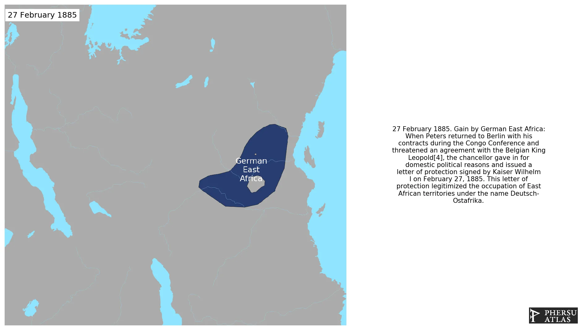
German East Africa : Maximal Extension of the Polity
German East Africa : Map showing the initial year each territory was ruled by the polity
German East Africa : Maximal Extension of the Polity
3. Monthly Summaries

4. Lists and Timelines
5. Rankings
 German East Africa : Top wars ordered by largest reached area
German East Africa : Top wars by territorial gain or loss in terms of area of the changes
German East Africa : Top wars by territorial gain or loss in terms of area difference
German East Africa : Top wars ordered by largest reached area
German East Africa : Top wars by territorial gain or loss in terms of area of the changes
German East Africa : Top wars by territorial gain or loss in terms of area difference
6. Time Series
German East Africa : Time Series of all Territorial Changes
German East Africa : time series of its population and area throughout history
7. All Events mentioned in Territorial Changes

8. All Cities mentioned in Territorial Changes
 Iringa
Mwanza
Arusha
Bukoba
Morogoro
Lubumbashi
Lindi
Lubumbashi
Lindi
Mahenge
Mahenge
Babati
Bagamoyo
Biharamulo
Geita
Ifakara
Itigi
Kahama
Kakonko
Kanyato
Kasulu
Kibaha
Kibiti
Mbumi
Kipili
Lindi
Manyoni
Masasi
Mbamba Bay
Mbeya
Mbulu
Mikumi
Mpwapwa
Mtwara
Musoma
Ngara
Oldeani
Nyahanga
Nzega
Oldeani
Same
Shinyanga
Sikonge
Singida
Songea
Sumbawanga
Tanga
Tunduma
Tunduru
Handeni
Biharamulo
Moshi
Ifakara
Njombe Mjini
Arusha
Same
Bagamoyo
Dar es Salaam
Kibaha
Kibiti
Korogwe
Lindi
Masasi
Mtwara
Tanga
Bubanza
Cankuzo
Gitega
Karuzi
Kayanza
Kirundo
Muramvya
Muyinga
Ngara
Ngozi
Rutana
Ruyigi
Geita
Bukoba
Bujumbura
Bururi
Kakonko
Kanyato
Kasulu
Kigoma
Makamba
Uvinza
Kipili
Morogoro
Tabora
Arusha
Kondoa-Irangi
Handeni
Bukoba
Malangali
Morogoro
Morogoro
Dar es Salaam
Dar es Salaam
Tabora
Bubanza
Bujumbura
Bururi
Butare
Buyumba
Cankuzo
Gikongoro
Gisenyi
Gitarama
Gitega
Goma
Karuzi
Kayanza
Kibungo
Kibuye
Kirundo
Makamba
Muramvya
Muyinga
Ngozi
Nyanza
Rutana
Ruyigi
Ngomano
Mbumi
Mikumi
Arusha
Mwanza
Mwanza
Mahenge
Dodoma
Ihanu
Dodoma
Ihanu
Dodoma
Ihanu
Dodoma
Ihanu
Morogoro
Malangali
Kondoa-Irangi
Tabora
Tunduma
Mwanza
Malangali
Arusha
Sumbawanga
Kigali
Kondoa-Irangi
Moshi
Babati
Dodoma
Itigi
Karema
Manyoni
Mbamba Bay
Mbeya
Mbulu
Mpanda
Mpwapwa
Musoma
Mwanza
Oldeani
Nyahanga
Nzega
Oldeani
Shinyanga
Singida
Songea
Tukuyu
Tunduru
Babati
Bagamoyo
Biharamulo
Geita
Ifakara
Itigi
Kahama
Kakonko
Kanyato
Kasulu
Kibaha
Kibiti
Mbumi
Kipili
Lindi
Manyoni
Masasi
Mbamba Bay
Mbeya
Mbulu
Mikumi
Mpwapwa
Mtwara
Musoma
Ngara
Oldeani
Nyahanga
Nzega
Oldeani
Same
Shinyanga
Sikonge
Singida
Songea
Sumbawanga
Tanga
Tunduma
Tunduru
Dar es Salaam
Dar es Salaam
Ujiji
Ujiji
Bukoba
Kondoa-Irangi
Mahenge
Malangali
Butare
Buyumba
Gikongoro
Gisenyi
Gitarama
Goma
Kibungo
Kibuye
Kigali
Nyanza
Ruhengeri
Moshi
Iringa
Kahama
Sikonge
Kigali
Lubumbashi
Lindi
Lubumbashi
Lindi
Bukoba
Iringa
Iringa
Mwanza
Arusha
Bukoba
Morogoro
Lubumbashi
Lindi
Lubumbashi
Lindi
Mahenge
Mahenge
Babati
Bagamoyo
Biharamulo
Geita
Ifakara
Itigi
Kahama
Kakonko
Kanyato
Kasulu
Kibaha
Kibiti
Mbumi
Kipili
Lindi
Manyoni
Masasi
Mbamba Bay
Mbeya
Mbulu
Mikumi
Mpwapwa
Mtwara
Musoma
Ngara
Oldeani
Nyahanga
Nzega
Oldeani
Same
Shinyanga
Sikonge
Singida
Songea
Sumbawanga
Tanga
Tunduma
Tunduru
Handeni
Biharamulo
Moshi
Ifakara
Njombe Mjini
Arusha
Same
Bagamoyo
Dar es Salaam
Kibaha
Kibiti
Korogwe
Lindi
Masasi
Mtwara
Tanga
Bubanza
Cankuzo
Gitega
Karuzi
Kayanza
Kirundo
Muramvya
Muyinga
Ngara
Ngozi
Rutana
Ruyigi
Geita
Bukoba
Bujumbura
Bururi
Kakonko
Kanyato
Kasulu
Kigoma
Makamba
Uvinza
Kipili
Morogoro
Tabora
Arusha
Kondoa-Irangi
Handeni
Bukoba
Malangali
Morogoro
Morogoro
Dar es Salaam
Dar es Salaam
Tabora
Bubanza
Bujumbura
Bururi
Butare
Buyumba
Cankuzo
Gikongoro
Gisenyi
Gitarama
Gitega
Goma
Karuzi
Kayanza
Kibungo
Kibuye
Kirundo
Makamba
Muramvya
Muyinga
Ngozi
Nyanza
Rutana
Ruyigi
Ngomano
Mbumi
Mikumi
Arusha
Mwanza
Mwanza
Mahenge
Dodoma
Ihanu
Dodoma
Ihanu
Dodoma
Ihanu
Dodoma
Ihanu
Morogoro
Malangali
Kondoa-Irangi
Tabora
Tunduma
Mwanza
Malangali
Arusha
Sumbawanga
Kigali
Kondoa-Irangi
Moshi
Babati
Dodoma
Itigi
Karema
Manyoni
Mbamba Bay
Mbeya
Mbulu
Mpanda
Mpwapwa
Musoma
Mwanza
Oldeani
Nyahanga
Nzega
Oldeani
Shinyanga
Singida
Songea
Tukuyu
Tunduru
Babati
Bagamoyo
Biharamulo
Geita
Ifakara
Itigi
Kahama
Kakonko
Kanyato
Kasulu
Kibaha
Kibiti
Mbumi
Kipili
Lindi
Manyoni
Masasi
Mbamba Bay
Mbeya
Mbulu
Mikumi
Mpwapwa
Mtwara
Musoma
Ngara
Oldeani
Nyahanga
Nzega
Oldeani
Same
Shinyanga
Sikonge
Singida
Songea
Sumbawanga
Tanga
Tunduma
Tunduru
Dar es Salaam
Dar es Salaam
Ujiji
Ujiji
Bukoba
Kondoa-Irangi
Mahenge
Malangali
Butare
Buyumba
Gikongoro
Gisenyi
Gitarama
Goma
Kibungo
Kibuye
Kigali
Nyanza
Ruhengeri
Moshi
Iringa
Kahama
Sikonge
Kigali
Lubumbashi
Lindi
Lubumbashi
Lindi
Bukoba