 Mecklenburg-Schwerin Duchy: All Data
This page is about the data available for this polity; the chronology of its events is available here.
Was a duchy of the Holy Roman Empire located in northern Germany. It separated and reunited several times with the Duchy of Mecklenburg, the final and definitive separation happening in 1701. It was elevated to Grand Duchy in 1815 and remained independent until 1871, when it joined the German Empire.
1. Genealogy

2. Maps of Political Control Over Time
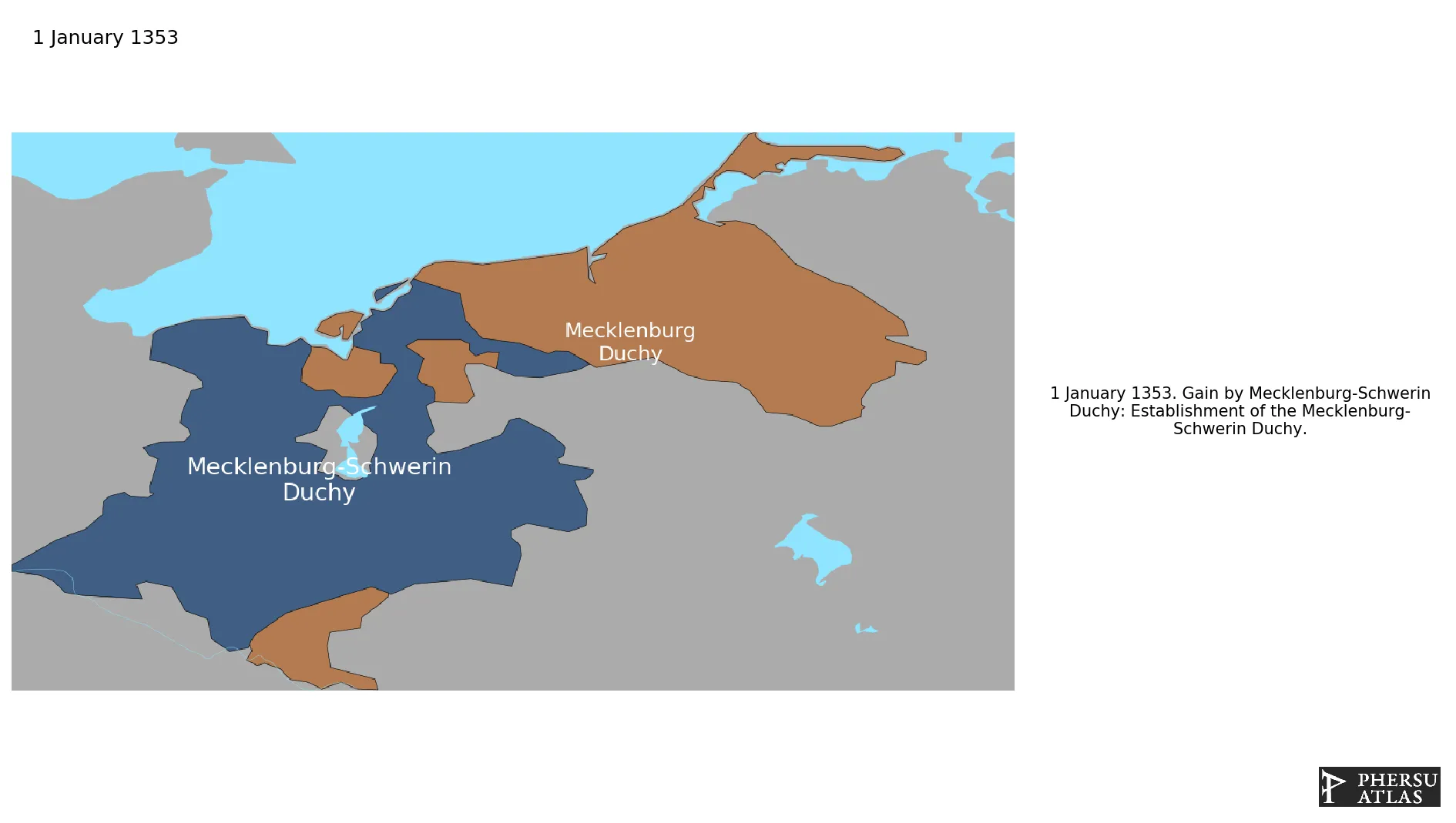
 Mecklenburg-Schwerin Duchy : Map showing the initial year each territory was ruled by the polity
Mecklenburg-Schwerin Duchy : Maximal Extension of the Polity
Mecklenburg-Schwerin Duchy : Map showing the initial year each territory was ruled by the polity
Mecklenburg-Schwerin Duchy : Maximal Extension of the Polity
3. Monthly Summaries

4. Lists and Timelines
5. Rankings
 Mecklenburg-Schwerin Duchy : Top wars ordered by largest reached area
Mecklenburg-Schwerin Duchy : Top wars by territorial gain or loss in terms of area of the changes
Mecklenburg-Schwerin Duchy : Top wars by territorial gain or loss in terms of area difference
Mecklenburg-Schwerin Duchy : Top wars ordered by largest reached area
Mecklenburg-Schwerin Duchy : Top wars by territorial gain or loss in terms of area of the changes
Mecklenburg-Schwerin Duchy : Top wars by territorial gain or loss in terms of area difference
6. Time Series
Mecklenburg-Schwerin Duchy : Time Series of all Territorial Changes
Mecklenburg-Schwerin Duchy : time series of its population and area throughout history
7. All Events mentioned in Territorial Changes

8. All Cities mentioned in Territorial Changes
 Gadebusch
Boizenburg
Schwerin
Parchim
Bad Doberan
Werle
Rostock
Güstrow
Malchow
Waren
Schwerin
Bad Doberan
Rostock
Wittstock
Boizenburg
Eger
Boizenburg
Parchim
Werle
Boizenburg
Schwerin
Parchim
Bad Doberan
Werle
Rostock
Rostock
Rostock
Gadebusch
Rostock
Boizenburg
Schwerin
Parchim
Bad Doberan
Werle
Rostock
Güstrow
Malchow
Waren
Parchim
Bad Doberan
Werle
Rostock
Lauenburg
Boizenburg
Schwerin
Wismar
Parchim
Bad Doberan
Werle
Rostock
Güstrow
Malchow
Waren
Boizenburg
Schwerin
Parchim
Bad Doberan
Werle
Rostock
Güstrow
Malchow
Waren
Bad Doberan
Boizenburg
Boizenburg
Parchim
Werle
Wismar
Boizenburg
Parchim
Werle
Gadebusch
Boizenburg
Schwerin
Parchim
Bad Doberan
Werle
Rostock
Güstrow
Malchow
Waren
Schwerin
Bad Doberan
Rostock
Wittstock
Boizenburg
Eger
Boizenburg
Parchim
Werle
Boizenburg
Schwerin
Parchim
Bad Doberan
Werle
Rostock
Rostock
Rostock
Gadebusch
Rostock
Boizenburg
Schwerin
Parchim
Bad Doberan
Werle
Rostock
Güstrow
Malchow
Waren
Parchim
Bad Doberan
Werle
Rostock
Lauenburg
Boizenburg
Schwerin
Wismar
Parchim
Bad Doberan
Werle
Rostock
Güstrow
Malchow
Waren
Boizenburg
Schwerin
Parchim
Bad Doberan
Werle
Rostock
Güstrow
Malchow
Waren
Bad Doberan
Boizenburg
Boizenburg
Parchim
Werle
Wismar
Boizenburg
Parchim
Werle