 Stem Duchy of Saxony: All Data
This page is about the data available for this polity; the chronology of its events is available here.
Was a medieval duchy located between the Lower Rhine and the Lower Elbe and Eider. It emerged from the settlement area of the Saxons, which was conquered in stages between 772 and 804 by Charlemagne and incorporated into the Frankish Empire.
1. Genealogy
2. Maps of Political Control Over Time
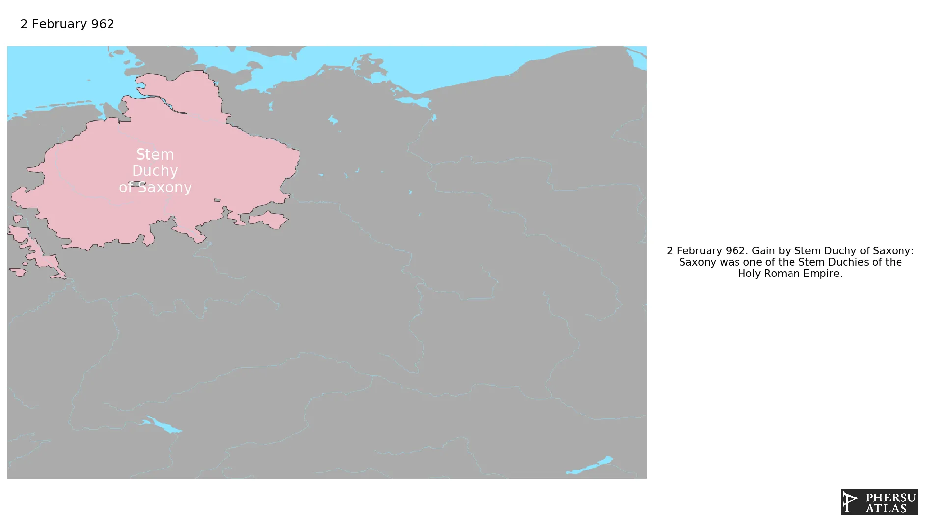
 Stem Duchy of Saxony : Map showing the initial year each territory was ruled by the polity
Stem Duchy of Saxony : Map depicting the polity's ruler in power when each territory was first controlled
Stem Duchy of Saxony : Maximal Extension of the Polity
Stem Duchy of Saxony : Map showing the initial year each territory was ruled by the polity
Stem Duchy of Saxony : Map depicting the polity's ruler in power when each territory was first controlled
Stem Duchy of Saxony : Maximal Extension of the Polity
3. Monthly Summaries

4. Lists and Timelines
 Stem Duchy of Saxony : List of events the polity was involved in
Stem Duchy of Saxony : List of Rulers
Stem Duchy of Saxony : Timeline of Rulers
Stem Duchy of Saxony : List of events the polity was involved in
Stem Duchy of Saxony : List of Rulers
Stem Duchy of Saxony : Timeline of Rulers
5. Rankings
 Stem Duchy of Saxony : Top rulers ordered by largest reached area
Stem Duchy of Saxony : Top wars ordered by largest reached area
Stem Duchy of Saxony : Top rulers by territorial gain or loss in terms of area difference
Stem Duchy of Saxony : Top wars by territorial gain or loss in terms of area of the changes
Stem Duchy of Saxony : Top wars by territorial gain or loss in terms of area difference
Stem Duchy of Saxony : Top rulers ordered by largest reached area
Stem Duchy of Saxony : Top wars ordered by largest reached area
Stem Duchy of Saxony : Top rulers by territorial gain or loss in terms of area difference
Stem Duchy of Saxony : Top wars by territorial gain or loss in terms of area of the changes
Stem Duchy of Saxony : Top wars by territorial gain or loss in terms of area difference
6. Time Series
Stem Duchy of Saxony : Time Series of all Territorial Changes
Stem Duchy of Saxony : time series of its population and area throughout history
7. All Events mentioned in Territorial Changes

8. All Cities mentioned in Territorial Changes
 Wernigerode
Nuremberg
Ingolstadt
Munich
Waldeck (Bavaria)
Regensburg
Rosenheim
Sulzbach-Rosenberg
Tegernsee
Kufstein
Mühldorf
Traunstein
Cham
Berchtsgaden
Gastein
Schaumberg
Wolpe
Stralsund
Bornhöved
Bad Segeberg
Bad Oldesloe
Lauenburg
Quedlinburg
Ahaus
Büren
Tecklenburg
Dassel
Arnsberg
Kiel
Bornhöved
Bad Segeberg
Bad Oldesloe
Pinneberg
Hamburg
Detmold
Blankenburg
Mansfeld
Everstein
Lübeck
Boizenburg
Ratzeburg
Schwerin
Meppen
Bad Bederkesa
Diepholz
Schaumberg
Waldeck (Bavaria)
Boizenburg
Schwerin
Demmin
Stralsund
Wolgast
Prenzlau
Stettin
Wollin
Kammin
Stargard in Pommern
Kolberg
Belgard
Köslin
Schlawe
Stolp
Schlochau
Bütow
Konitz
Lauenburg in Pommern
Czersk
Gdynia
Rosenheim
Tegernsee
Sulzbach-Rosenberg
Lüchow
Wohldenberg
Brixen
Cologne
Bonn
Paderborn
Zülpich
Kaiserswerth
Cologne
Recklinghausen
Soest
Osnabrück
Kolberg
Köslin
Bremen
Meldorf
Stade
Halberstadt
Haldensleben
Lübeck
Magdeburg
Halle (Saale)
Ziesar
Rathenow
Jüterbog
Vechta
Bielefeld
Minden
Oldenburg
Nuremberg
Ingolstadt
Munich
Regensburg
Moosburg
Kufstein
Mühldorf
Traunstein
Cham
Berchtsgaden
Gastein
Demmin
Wolgast
Prenzlau
Stettin
Wollin
Kammin
Stargard in Pommern
Belgard
Schlawe
Stolp
Schlochau
Bütow
Konitz
Lauenburg in Pommern
Czersk
Gdynia
Querfurt
Altena
Attendorn
Dortmund
Bilstein
Lauenburg
Ratzeburg
Hildesheim
Wittenberg
Gommern
Wittenberg
Münster
Coesfeld
Lauenburg
Ratzeburg
Dannenberg
Corvey
Steinfurt
Sternberg
Waldeck
Verden
Salzwedel
Gardelegen
Osterburg
Stendal
Pritzwalk
Bad Bentheim
Lauenburg
Ratzeburg
Bruchhausen-Vilsen
Hoya
Celle
Lüneburg
Braunschweig
Gifhorn
Hanover
Einbeck
Göttingen
Wittenberg
Celle
Kiel
Wohldenberg
Lüneburg
Braunschweig
Gifhorn
Wernigerode
Blankenburg
Halberstadt
Dannenberg
Quedlinburg
Salzwedel
Lüchow
Gardelegen
Haldensleben
Mansfeld
Querfurt
Magdeburg
Osterburg
Stendal
Cologne
Bonn
Meppen
Dortmund
Münster
Tecklenburg
Osnabrück
Oldenburg
Vechta
Diepholz
Bielefeld
Büren
Paderborn
Bremen
Bad Bederkesa
Detmold
Minden
Bruchhausen-Vilsen
Sternberg
Waldeck
Meldorf
Hoya
Verden
Wolpe
Corvey
Stade
Everstein
Dassel
Hanover
Pinneberg
Einbeck
Göttingen
Hildesheim
Hamburg
Zülpich
Kaiserswerth
Cologne
Ahaus
Bad Bentheim
Coesfeld
Recklinghausen
Steinfurt
Altena
Attendorn
Bilstein
Arnsberg
Soest
Wernigerode
Nuremberg
Ingolstadt
Munich
Waldeck (Bavaria)
Regensburg
Rosenheim
Sulzbach-Rosenberg
Tegernsee
Kufstein
Mühldorf
Traunstein
Cham
Berchtsgaden
Gastein
Schaumberg
Wolpe
Stralsund
Bornhöved
Bad Segeberg
Bad Oldesloe
Lauenburg
Quedlinburg
Ahaus
Büren
Tecklenburg
Dassel
Arnsberg
Kiel
Bornhöved
Bad Segeberg
Bad Oldesloe
Pinneberg
Hamburg
Detmold
Blankenburg
Mansfeld
Everstein
Lübeck
Boizenburg
Ratzeburg
Schwerin
Meppen
Bad Bederkesa
Diepholz
Schaumberg
Waldeck (Bavaria)
Boizenburg
Schwerin
Demmin
Stralsund
Wolgast
Prenzlau
Stettin
Wollin
Kammin
Stargard in Pommern
Kolberg
Belgard
Köslin
Schlawe
Stolp
Schlochau
Bütow
Konitz
Lauenburg in Pommern
Czersk
Gdynia
Rosenheim
Tegernsee
Sulzbach-Rosenberg
Lüchow
Wohldenberg
Brixen
Cologne
Bonn
Paderborn
Zülpich
Kaiserswerth
Cologne
Recklinghausen
Soest
Osnabrück
Kolberg
Köslin
Bremen
Meldorf
Stade
Halberstadt
Haldensleben
Lübeck
Magdeburg
Halle (Saale)
Ziesar
Rathenow
Jüterbog
Vechta
Bielefeld
Minden
Oldenburg
Nuremberg
Ingolstadt
Munich
Regensburg
Moosburg
Kufstein
Mühldorf
Traunstein
Cham
Berchtsgaden
Gastein
Demmin
Wolgast
Prenzlau
Stettin
Wollin
Kammin
Stargard in Pommern
Belgard
Schlawe
Stolp
Schlochau
Bütow
Konitz
Lauenburg in Pommern
Czersk
Gdynia
Querfurt
Altena
Attendorn
Dortmund
Bilstein
Lauenburg
Ratzeburg
Hildesheim
Wittenberg
Gommern
Wittenberg
Münster
Coesfeld
Lauenburg
Ratzeburg
Dannenberg
Corvey
Steinfurt
Sternberg
Waldeck
Verden
Salzwedel
Gardelegen
Osterburg
Stendal
Pritzwalk
Bad Bentheim
Lauenburg
Ratzeburg
Bruchhausen-Vilsen
Hoya
Celle
Lüneburg
Braunschweig
Gifhorn
Hanover
Einbeck
Göttingen
Wittenberg
Celle
Kiel
Wohldenberg
Lüneburg
Braunschweig
Gifhorn
Wernigerode
Blankenburg
Halberstadt
Dannenberg
Quedlinburg
Salzwedel
Lüchow
Gardelegen
Haldensleben
Mansfeld
Querfurt
Magdeburg
Osterburg
Stendal
Cologne
Bonn
Meppen
Dortmund
Münster
Tecklenburg
Osnabrück
Oldenburg
Vechta
Diepholz
Bielefeld
Büren
Paderborn
Bremen
Bad Bederkesa
Detmold
Minden
Bruchhausen-Vilsen
Sternberg
Waldeck
Meldorf
Hoya
Verden
Wolpe
Corvey
Stade
Everstein
Dassel
Hanover
Pinneberg
Einbeck
Göttingen
Hildesheim
Hamburg
Zülpich
Kaiserswerth
Cologne
Ahaus
Bad Bentheim
Coesfeld
Recklinghausen
Steinfurt
Altena
Attendorn
Bilstein
Arnsberg
Soest