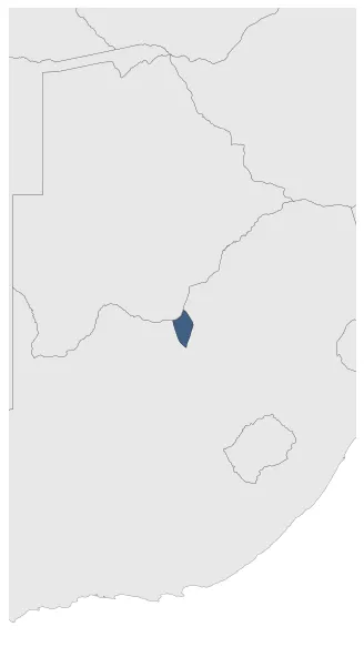
State of Goshen
If you are looking for the page with the statistics about this polity you can find it here:All Statistics
Was a Boer Republic (independent republics formed by Durch-speaking inhabitants of the Cape Colony that wanted to be independent from the British Cape Colony).
Establishment
October 1882: In the mid-nineteenth century, Voortrekkers (Boer settlers) established themselves in the region of Goshen and in the early 1880s they supported Moshoette in his battles against Mankurwane and Montshiwa, helping to besiege Montshiwa’s stronghold Mahikeng. Mahikeng fell on 24 October 1882 and, in gratitude, Moshoette ceded large portions of Mankurwane's land (416 farms of 3,000 morgen (2,563 hectares) each) to the Boer mercenaries who had supported him.
Chronology
Interactive Chronologies with maps are available in the section Changes Navigation
1. Events
August 1883: Less than a year after declaring independence, Goshen and the neighbouring Republic of Stellaland united to form the United States of Stellaland.
Disestablishment
August 1883: Less than a year after declaring independence, Goshen and the neighbouring Republic of Stellaland united to form the United States of Stellaland.