Werdenberg County
If you are looking for the page with the statistics about this polity you can find it here:All Statistics
Was a county of the Holy Roman Empire.
Establishment
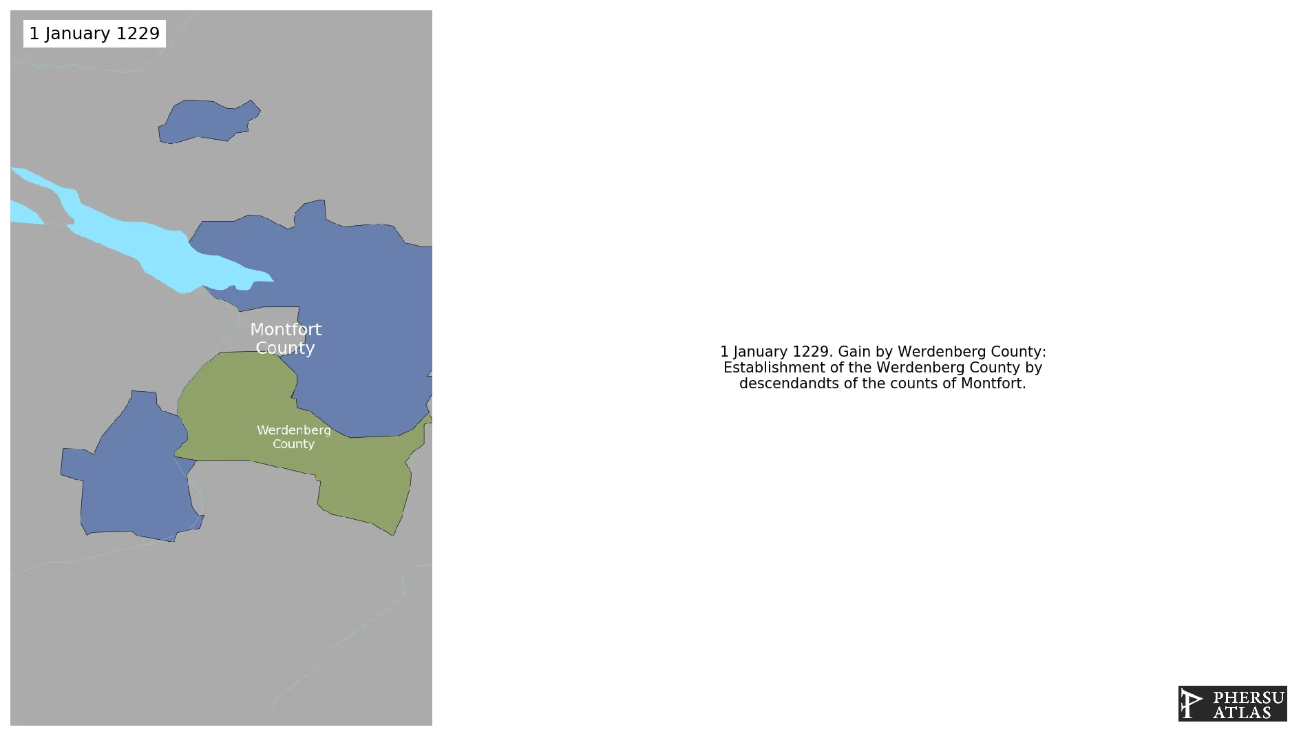
January 1229: Establishment of the Werdenberg County by descendandts of the counts of Montfort.
Chronology
Interactive Chronologies with maps are available in the section Changes Navigation
1. Events
January 1278: The rulers of Heiligenberg became extinct and the County fell to the Werdenberg County.
January 1309: Heiligenberg is established as an independent county by the counts of Werdenberg-Heiligenberg.
January 1316: Splügen is acquired by Werdenberg.
January 1376: Montfort-Feldkirch is sold to Austria.
January 1379: Based on Gustav Droysen's Map of the Holy Roman Empire in the XIV century.
January 1397: Vaduz County gains imperial immediacy.
April 1399: On April 4, 1399, the ruler of Hohentrins (who was sworn to the Count of Werdenberg-Heiligenburg) and the people of Trin, Tamins and the toll bridge to Reichenau joined the League of God's House.
January 1400: In Stuttgart could not do much with the lordship of Veringen, which was located away from the heartland, and in 1399 it was pledged to Count Eberhard von Werdenberg.
January 1400: Werdenberg County acquired Sigmaringen and Veringen.
January 1414: Werdenberg-Heiligenberg is sold to Austria.
January 1425: In 1424 the communities of the Hinterrhein valley, Heinzenberg-Thusis, Schams and Rheinwald, joined the Grey League.
January 1437: In 1615 the city of Zurich acquired the County of Toggenburg.
January 1467: After several changes of ownership, Count Hugo von Werdenberg sold Belfort to Sigmund of Austria in 1466.
January 1478: Based on Gustav Droysen's Map of the Holy Roman Empire in the XV century.
Disestablishment
January 1536: Via the Counts of Werdenberg, Sigmaringen came to the Hohenzollern family in 1535.
Selected Sources
Droysen, G. (1886): Historischer Handatlas, Bielefeld and Leipzig (Germany)
Droysen, G. (1886): Historischer Handatlas, Bielefeld and Leipzig (Germany), pp. 30-31
Droysen, G. (1886): Historischer Handatlas, Bielefeld and Leipzig (Germany), pp. 34-35