 Duchy of Pomerania: All Data
This page is about the data available for this polity; the chronology of its events is available here.
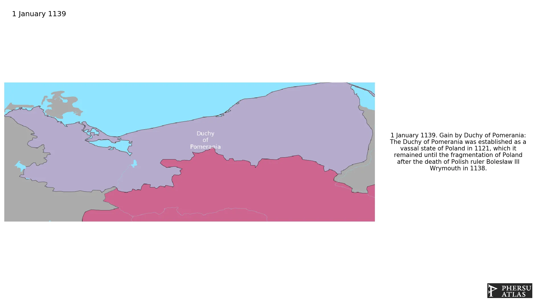
Was a duchy in Pomerania on the southern coast of the Baltic Sea, ruled by dukes of the House of Pomerania (Griffins). It was partitioned and reunited several times. We only take in account the partition into the Stettin and Wolgast Lines based on G. Droysen's “Historischer Handatlas” (1886). In fact, none of the partitions had a hereditary character. The only exception was during a war with the Margraviate of Brandenburg, when in 1338 Barnim III of Pomerania-Stettin was granted his partition as a fief directly from the Holy Roman Emperor. Pomerania became a vassal of Brandenburg after the War of the Succession of Stettin.
1. Genealogy

2. Maps of Political Control Over Time
 Duchy of Pomerania : Map showing the initial year each territory was ruled by the polity
Duchy of Pomerania : Maximal Extension of the Polity
Duchy of Pomerania : Map showing the initial year each territory was ruled by the polity
Duchy of Pomerania : Maximal Extension of the Polity
3. Monthly Summaries

4. Lists and Timelines
5. Rankings
 Duchy of Pomerania : Top wars ordered by largest reached area
Duchy of Pomerania : Top wars by territorial gain or loss in terms of area of the changes
Duchy of Pomerania : Top wars by territorial gain or loss in terms of area difference
Duchy of Pomerania : Top wars ordered by largest reached area
Duchy of Pomerania : Top wars by territorial gain or loss in terms of area of the changes
Duchy of Pomerania : Top wars by territorial gain or loss in terms of area difference
6. Time Series
Duchy of Pomerania : Time Series of all Territorial Changes
Duchy of Pomerania : time series of its population and area throughout history
7. All Events mentioned in Territorial Changes
 Danish invasion of northern Germany (1201)
First Mongol Invasion of Germany
Teutonic takeover of Danzig (Gdańsk)
First War of the Rügen Succession
Second War of the Rügen Succession
War of the Succession of Stettin
Danish invasion of northern Germany (1201)
First Mongol Invasion of Germany
Teutonic takeover of Danzig (Gdańsk)
First War of the Rügen Succession
Second War of the Rügen Succession
War of the Succession of Stettin
8. All Cities mentioned in Territorial Changes
 Demmin
Stralsund
Wolgast
Prenzlau
Stettin
Wollin
Kammin
Stargard in Pommern
Kolberg
Belgard
Köslin
Schlawe
Stolp
Schlochau
Bütow
Konitz
Lauenburg in Pommern
Czersk
Gdynia
Demmin
Wolgast
Prenzlau
Stettin
Wollin
Kammin
Stargard in Pommern
Belgard
Schlawe
Stolp
Schlochau
Bütow
Konitz
Lauenburg in Pommern
Czersk
Gdynia
Demmin
Wolgast
Wollin
Kammin
Belgard
Schlawe
Stolp
Demmin
Wolgast
Wollin
Kammin
Belgard
Schlawe
Stolp
Demmin
Wolgast
Prenzlau
Stettin
Wollin
Kammin
Stargard in Pommern
Belgard
Schlawe
Stolp
Schlochau
Bütow
Konitz
Lauenburg in Pommern
Czersk
Gdynia
Demmin
Wolgast
Prenzlau
Stettin
Wollin
Kammin
Stargard in Pommern
Belgard
Schlawe
Stolp
Schlochau
Bütow
Konitz
Lauenburg in Pommern
Czersk
Gdynia
Schlochau
Bütow
Konitz
Lauenburg in Pommern
Czersk
Gdynia
Stralsund
Demmin
Stralsund
Demmin
Stralsund
Kostrzyn nad Odrą
Landsberg an der Warthe
Arnswalde
Kostrzyn nad Odrą
Landsberg an der Warthe
Arnswalde
Demmin
Stralsund
Wolgast
Stettin
Wollin
Kammin
Stargard in Pommern
Belgard
Schlawe
Stolp
Prenzlau
Demmin
Stralsund
Wolgast
Prenzlau
Stettin
Wollin
Kammin
Stargard in Pommern
Kolberg
Belgard
Köslin
Schlawe
Stolp
Schlochau
Bütow
Konitz
Lauenburg in Pommern
Czersk
Gdynia
Demmin
Wolgast
Prenzlau
Stettin
Wollin
Kammin
Stargard in Pommern
Belgard
Schlawe
Stolp
Schlochau
Bütow
Konitz
Lauenburg in Pommern
Czersk
Gdynia
Demmin
Wolgast
Wollin
Kammin
Belgard
Schlawe
Stolp
Demmin
Wolgast
Wollin
Kammin
Belgard
Schlawe
Stolp
Demmin
Wolgast
Prenzlau
Stettin
Wollin
Kammin
Stargard in Pommern
Belgard
Schlawe
Stolp
Schlochau
Bütow
Konitz
Lauenburg in Pommern
Czersk
Gdynia
Demmin
Wolgast
Prenzlau
Stettin
Wollin
Kammin
Stargard in Pommern
Belgard
Schlawe
Stolp
Schlochau
Bütow
Konitz
Lauenburg in Pommern
Czersk
Gdynia
Schlochau
Bütow
Konitz
Lauenburg in Pommern
Czersk
Gdynia
Stralsund
Demmin
Stralsund
Demmin
Stralsund
Kostrzyn nad Odrą
Landsberg an der Warthe
Arnswalde
Kostrzyn nad Odrą
Landsberg an der Warthe
Arnswalde
Demmin
Stralsund
Wolgast
Stettin
Wollin
Kammin
Stargard in Pommern
Belgard
Schlawe
Stolp
Prenzlau