Most recent flag or coat of arms
Maximum Extent
Maximum Extent (Interactive Map)

Data

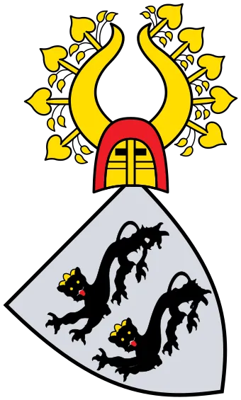
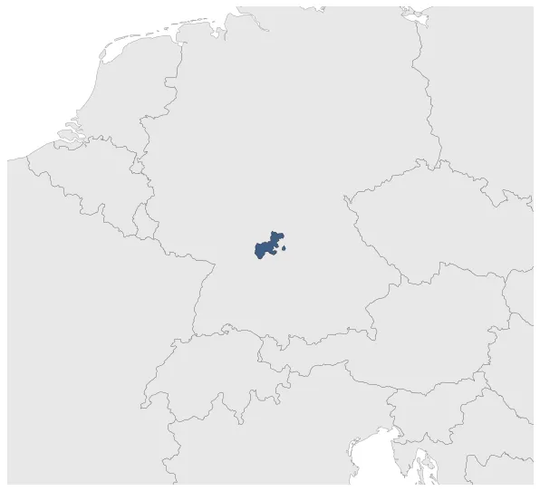
Name: Principality of Hohenlohe

Type: Polity

Start: 1744 AD

End: 1806 AD

Nation: hohenlohe

Statistics

All Statistics: All Statistics

Icon Principality of Hohenlohe

This article is about the specific polity Principality of Hohenlohe and therefore only includes events related to its territory and not to its possessions or colonies. If you are interested in the possession, this is the link to the article about the nation which includes all possessions as well as all the different incarnations of the nation.

If you are looking for the page with the statistics about this polity you can find it here:All Statistics

Was a county, and later a principality of the Holy Roman Empire, located in southwest Germany.

Establishment


  • May 1744: Hohenlohe is raised to principality.
  • Chronology


    Interactive Chronologies with maps are available in the section Changes Navigation

    1. French Revolutionary and Napoleonic Wars


    Were a series of conflicts between France and several European monarchies between 1792 and 1815. They encompass first the French Revolutionary Wars against the newly declared French Republic and from 1803 onwards the Napoleonic Wars against First Consul and later Emperor Napoleon Bonaparte. They include the Coalition Wars as a subset: seven wars waged by various military alliances of great European powers, known as Coalitions, against Revolutionary France - later the First French Empire - and its allies.

  • January 1807: In 1806, the various Hohenlohe territories were divided between the Kingdom of Württemberg and the Kingdom of Bavaria. This decision was made as part of the territorial reorganization following the dissolution of the Holy Roman Empire.
  • January 1807: In 1806, the different Hohenlohe territories, ruled by the Hohenlohe family, were divided between the Kingdom of Württemberg and the Kingdom of Bavaria as a result of the territorial changes brought about by the dissolution of the Holy Roman Empire.

  • 2. Further events (Unrelated to Any War)


  • January 1788: Based on Gustav Droysen's Map of the Holy Roman Empire in the XVIII century.

  • Disestablishment


  • January 1807: In 1806, the various Hohenlohe territories were divided between the Kingdom of Württemberg and the Kingdom of Bavaria. This decision was made as part of the territorial reorganization following the dissolution of the Holy Roman Empire.
  • January 1807: In 1806, the different Hohenlohe territories, ruled by the Hohenlohe family, were divided between the Kingdom of Württemberg and the Kingdom of Bavaria as a result of the territorial changes brought about by the dissolution of the Holy Roman Empire.
  • Selected Sources


  • Droysen, G. (1886): Historischer Handatlas, Bielefeld and Leipzig (Germany), pp. 46-47
  • All Phersu Atlas Regions

    Africa

    Americas

    Asia

    Europe

    Oceania