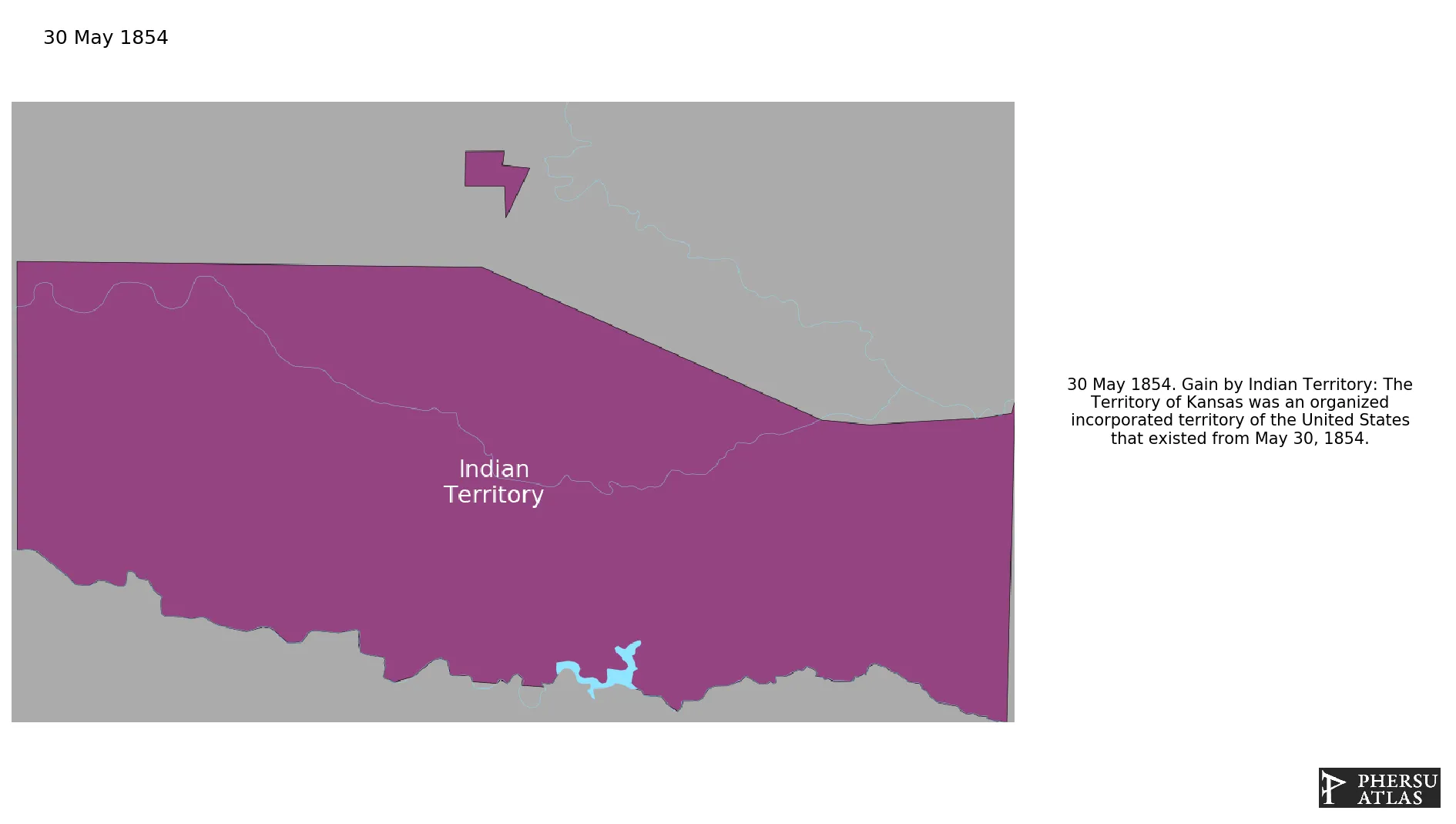
Indian Territory
If you are looking for the page with the statistics about this polity you can find it here:All Statistics
Was an organized incorporated territory of the United States.
Establishment
May 1854: The Territory of Kansas was an organized incorporated territory of the United States that existed from May 30, 1854.
Chronology
Interactive Chronologies with maps are available in the section Changes Navigation
Was a civil war in the United States of America between the central government (Unionists) and the secessionist Confederate States of America that occupied the southern States. The main cause of the war was the different economic system of the northern and southern states: the northern states were industrialized and had abolished slavery, whereas the southern states relied on slavery to run its plantation agriculture based economy. At the end of the war the Union occupied the southern states and slavery was abolished. .
1.1.Trans-Mississippi Theatre
Was the theatre of war west of the Mississippi River during the American Civil War.
June 1865: At Fort Towson in Choctaw lands, General Stand Watie officially became the last Confederate general to surrender on June 25, 1865.
June 1855: Indian Land Cessions in the U.S., 1784 to 1894
December 1861: In 1861, the Confederate States of America ratified treaties with the Osage, Seneca, and Shawnee tribes in what is now Oklahoma. The treaties were negotiated by Confederate Commissioner Albert Pike and aimed to secure alliances with Native American tribes during the Civil War.
December 1861: In 1861, the Confederate States ratified treaties with the Cherokee and Seminole tribes, granting them representation in the Confederate Congress. This move aimed to secure the support of Native American tribes during the American Civil War.
December 1861: The Confederate States ratified treaties with the Choctaw and Chickasaw, granting them a delegate in the Congress of the Confederate States; with the Comanche; with the Creek, granting them a delegate to be shared with the Seminole; and the Quapaw.
March 1866: Indian Land Cessions in the U.S., 1784 to 1894
April 1866: Indian Land Cessions in the U.S., 1784 to 1894
June 1866: Indian Land Cessions in the U.S., 1784 to 1894
July 1866: Indian Land Cessions in the U.S., 1784 to 1894
July 1866: Indian Land Cessions in the U.S., 1784 to 1894
February 1867: Indian Land Cessions in the U.S., 1784 to 1894
February 1867: U.S. treaty concluded at Washington, D. C., with the Seneka, Mixed Seneka, and Shawnee, Quapaw, Peoria, Kaskaskia, Piankishaw, Wea, Ottawa of Blanchard's fork and Roche de Boeuf, and certain Wyandot.
February 1867: Indian Land Cessions in the U.S., 1784 to 1894
October 1867: The Medicine Lodge Treaty is the overall name for three treaties signed near Medicine Lodge, Kansas, between the Federal government of the United States and southern Plains Indian tribes in October 1867
August 1869: Indian Land Cessions in the U.S., 1784 to 1894
June 1872: Indian Land Cessions in the U.S., 1784 to 1894
September 1872: Indian Land Cessions in the U.S., 1784 to 1894
April 1876: Indian Land Cessions in the U.S., 1784 to 1894
May 1878: Indian Land Cessions in the U.S., 1784 to 1894
March 1881: Indian Land Cessions in the U.S., 1784 to 1894
August 1883: Indian Land Cessions in the U.S., 1784 to 1894
July 1884: Indian Land Cessions in the U.S., 1784 to 1894
March 1889: Indian Land Cessions in the U.S., 1784 to 1894
May 1890: Oklahoma Territory was organized.
May 1890: Western half of Indian Territory, except for the Cherokee Outlet, becomes part of the Oklahoma territory.
September 1893: Per a treaty with the Cherokee, the federal government purchased the Cherokee Outlet in the Indian Territory and opened it to settlement, transferring it to Oklahoma Territory as provided in the Oklahoma Organic Act.
November 1907: Indian Territory and Oklahoma Territory were combined and admitted as the forty-sixth state, Oklahoma.
Disestablishment
November 1907: Indian Territory and Oklahoma Territory were combined and admitted as the forty-sixth state, Oklahoma.
Selected Sources
Royce, C. C. (1899): Indian Land Cessions in the United States, Eighteenth Annual Report of the Bureau of American Ethnology to the Secretary of the Smithsonian Institution, p. 842
Van Zandt, Franklin K. (1976). Boundaries of the United States and the Several States: With Miscellaneous Geographic Information Concerning Areas, Altitudes, and Geographic Centers. Washington, D.C.: U.S. Government Printing Office. pp. 139-141

.svg.png.webp)