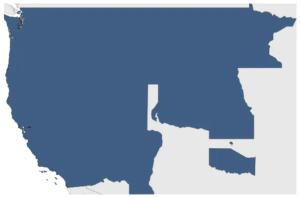
Unorganized Territory
If you are looking for the page with the statistics about this polity you can find it here:All Statistics
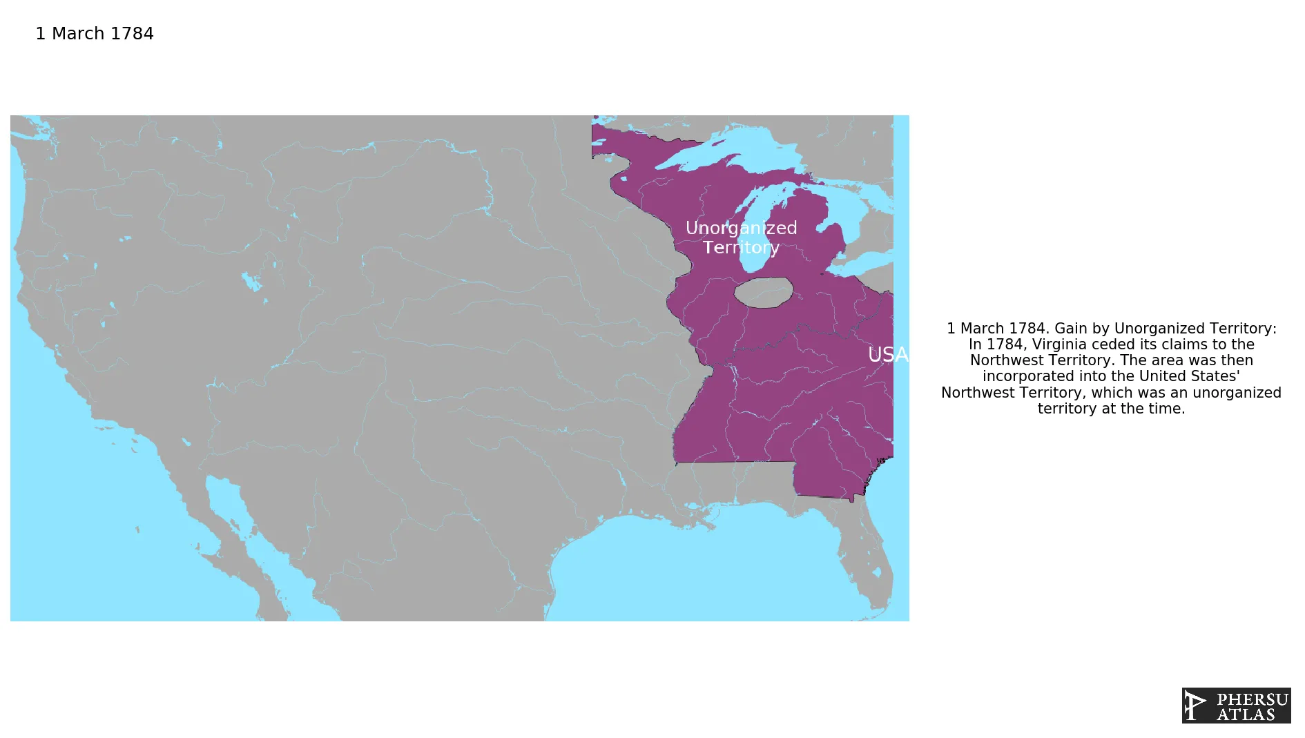
All the incorporated territories of the United States that were not organized.
Establishment
March 1784: In 1784, Virginia ceded its claims to the Northwest Territory. The area was then incorporated into the United States' Northwest Territory, which was an unorganized territory at the time.
Chronology
Interactive Chronologies with maps are available in the section Changes Navigation
Were two border disputes that involved Spain and the United States in relation to the region known as West Florida.
1.1.Second West Florida Controversy
The United States occupied West Florida, a disputed territory, taking advantage of the Peninsular War that Spain was fighting against Napoleonic forces.
February 1821: The Adams-Onís Treaty was negotiated between Secretary of State John Quincy Adams and Spanish minister Luis de Onís. The treaty resulted in the transfer of East and West Florida to the United States in 1821 in exchange for the US dropping claims of spoliation against Spain.
Were a series of secessions and revolts against the centralist government of Mexico in the period 1835-1846.
2.1.Mexican-American War
Was a war between the United States of America and Mexico caused by the U.S. annexion of Texas, a country that had seceded from Mexico, and by the American aim to annex California and Oregon.
2.1.1.Treaty of Guadalupe Hidalgo
Was a peace treaty signed on February 2, 1848, in the Villa de Guadalupe Hidalgo (now a neighborhood of Mexico City) between the United States and Mexico that ended the Mexican-American War (1846-1848). It gave the United States the Rio Grande as a boundary for Texas, and gave the U.S. ownership of California and a large area comprising roughly half of New Mexico, most of Arizona, Nevada, and Utah and Colorado.
May 1848: The Treaty of Guadalupe Hidalgo is the peace treaty signed on February 2, 1848, in the Villa de Guadalupe Hidalgo between the United States and Mexico that ended the Mexican-American War. The ratifications were exchanged on May 30, and the treaty was proclaimed on July 4, 1848. t gave the United States the Rio Grande as a boundary for Texas, and gave the U.S. ownership of California and a large area comprising roughly half of New Mexico, most of Arizona, Nevada, and Utah and Colorado.
January 1785: The United States and the Iroquois, led by Chief Cornplanter, signed the treaty of Fort Stanwix in 1784. The Iroquois Confederacy ceded a large portion of their territory, including present-day western New York, to the United States in exchange for peace and protection.
January 1785: Iroquois claims relinquished to Great Britain in 1784.
July 1787: The region lying west of Pennsylvania, north of the Ohio River, east of the Mississippi River, and south of the Great Lakes, became the Northwest Territory by an Act of Congress in 1787.
April 1790: North Carolina ceded its western half to the federal government.
May 1790: In 1790, the land recently ceded by North Carolina was organized as the Southwest Territory. This territory was governed by William Blount, a prominent politician and land speculator, who played a key role in its development and eventual admission to the Union as the state of Tennessee.
April 1812: The southeastern remainder of the Orleans Territory became unorganized territory, as it had no definition for a short time.
December 1816: In 1816, the remnant part of the Indiana Territory became the Unorganized Territory. This was a result of the passage of the Enabling Act of 1816, which allowed Indiana to become a state and left the remaining land as unorganized territory. This territory eventually became part of future states such as Illinois, Michigan, and Wisconsin.
December 1818: The unorganized territory that was recently part of Indiana Territory, was assigned to Michigan Territory.
August 1821: In 1821, the southeastern corner of Missouri Territory was admitted as the twenty-fourth state, Missouri, while the rest of the territory became unorganized Territory.
September 1821: Indian Land Cessions in the U.S., 1784 to 1894
February 1822: The Adams-Onís Treaty was signed between the United States and Spain, with John Quincy Adams representing the U.S. and Luis de Onís representing Spain. The treaty established the border between Spanish Texas and the United States at the Sabine River, leading to the transfer of the territory to the USA in 1822.
March 1822: The Territory of Florida was established in 1822, with William Pope Duval serving as the first governor. It was a significant step towards Florida eventually becoming a state in 1845.
May 1824: In 1824, the westernmost portion of the Arkansas Territory was removed and became part of the Unorganized Territory.
June 1824: In 1824, Michigan Territory gained a large parcel of land from unorganized territory, extending west to the Missouri River and White Earth River.
June 1825: The Osages ceded their traditional lands across Missouri, Arkansas, and Oklahoma to the U.S.A. in the treaties of 1818 and 1825
June 1825: U.S. treaty concluded at st. Louis (Missouri) with the Kansas.
May 1828: A westernmost portion of Arkansas, known as the "Cherokee Outlet", was removed on May 6, 1828, reducing the territory to the extent of the present state of Arkansas.
May 1828: U.S. treaty concluded at Washington D.C. with the Cherokee nation west of Mississippi river.
July 1830: U.S. treaty concluded at Prairie du Chien (Michigan Territory) with the Sauk and Fox, Medewakanton, Wahpekuta, Wahpeton and Sieseton bands of Sioux, Omaha, Iowa, Oto and Missouri.
September 1833: U.S. treaty concluded at Oto village on the Platte with the Oto and Missouri.
October 1833: U.S. treaty concluded at Grand Pawnee village on Platte river with the confederated bands of Pawnees.
January 1837: The Cherokee Outlet, or Cherokee Strip, was located in what is now the state of Oklahoma in the United States. It was a sixty-mile (97 km) wide parcel of land south of the Oklahoma-Kansas border between the 96th and 100th meridians. The Cherokee Outlet was created in 1836.
March 1837: The Platte Purchase transferred some land from unorganized territory to northwest Missouri, extending its northern border west to the Missouri.
January 1838: U.S. treaty concluded at Buffalo Creek (New York) with several tribes of New York.
January 1840: The Trail of Tears was the forced relocation of approximately 60,000 Native Americans in the United States from their ancestral homelands in the Southeastern United States to the Cherokee territory in Oklahoma.
December 1842: Indian Land Cessions in the U.S., 1784 to 1894
January 1846: U.S. treaty concluded at the Methodist mission in the Kansas country with the Kansa.
January 1846: Indian Land Cessions in the U.S., 1784 to 1894
June 1846: The Oregon Treaty is a treaty between Great Britain and the United States that was signed on June 15, 1846, in Washington, D.C.. The treaty brought an end to the Oregon boundary dispute by settling competing American and British claims to the Oregon Country.
December 1846: In 1846, the portion of Iowa Territory south of 43°30′ north and east of the Big Sioux River was admitted as the twenty-ninth state, Iowa. The remaining territory became unorganized, with no established government or boundaries.
May 1848: On May 29, 1848, an eastern portion of the Wisconsin Territory was admitted to the Union as the State of Wisconsin. What remained of the Wisconsin territory became Unorganized Territory.
August 1848: U.S. treaty concluded at Fort Childs on Grand Island with the Pawnee.
August 1848: The Territory of Oregon was an organized incorporated territory of the United States that existed from August 14, 1848, until February 14, 1859, when the southwestern portion of the territory was admitted to the Union as the State of Oregon.
March 1849: The Minnesota Territory was organized.
April 1849: In 1849, the border between California and the Utah Territory was defined by geographical coordinates that were not surveyed. On April 26, 1856, local residents took advantage of this ambiguity and justified their resistance to tax collectors from Plumas County, California, by proclaiming themselves part of a new "Territory of Nataqua." .
April 1850: The secession of the Great Republic of Rough and Ready in 1850 was led by the residents of the mining town in California, including Colonel E.F. Brundage and Captain A.A. Townsend. They declared independence to avoid paying high mining taxes imposed by the state government.
July 1850: In 1850, the Great Republic of Rough and Ready rejoined the Union after being an independent territory. This decision was made following the signing of the Compromise of 1850, which resolved several issues related to the expansion of slavery in the United States.
September 1850: In 1850, the US Congress organized the portion of land north of 37° north and west of the Rocky Mountains as Utah Territory. This decision was made as part of the Compromise of 1850, which aimed to address the issue of slavery in newly acquired territories.
September 1850: In 1850, California was admitted as the thirty-first state of the USA.
December 1850: In 1850, part of the Minnesota Territory became unorganized. This change was a result of the signing of the Minnesota Enabling Act by President Millard Fillmore and the subsequent organization of the Minnesota Territory.
December 1850: As part of the Compromise of 1850, the remaining unorganized territory from the Mexican Cession was added to the New Mexico Territory.
September 1851: The Fort Laramie Treaty of 1851 was signed on September 17, 1851 between United States treaty commissioners and representatives of the Cheyenne, Sioux, Arapaho, Crow, Assiniboine, Mandan, Hidatsa, and Arikara Nations.
March 1854: Indian Land Cessions in the U.S., 1784 to 1894
March 1854: U.S. treaty concluded at Washington, D. C. with the Omaha.
May 1854: U.S. treaty concluded at Washington, D. C. with the Delaware.
May 1854: U.S. treaty concluded at Washington, D. C. with the Shawnee.
May 1854: U.S. treaty concluded at Washington, D. C. with the Iowa.
May 1854: Indian Land Cessions in the U.S., 1784 to 1894
May 1854: The Territory of Nebraska was an organized incorporated territory of the United States that existed from May 30, 1854, until March 1, 1867, when the final extent of the territory was admitted to the Union as the State of Nebraska.
May 1854: The Territory of Kansas was an organized incorporated territory of the United States that existed from May 30, 1854.
June 1854: Antonio López de Santa Anna signed a treaty with James Gadsden, the U.S. Ambassador to Mexico, which involved the sale of an area of 76,845 square kilometres from the states of Sonora and Chihuahua to the United States for $10 million. This treaty became known as the Gadsden Purchase.
August 1854: The recently obtained Gadsden Purchase was assigned to New Mexico Territory.
May 1858: In 1858, after the Minnesota Territory was admitted as a state, the remaining land became unorganized territory.
January 1861: After Kansas was admitted as a state in 1861, the remaining territories became unorganized territory.
February 1861: The Territory of Colorado was created to govern the western region of the former Kansas Territory on February 28, 1861. This decision was made by President James Buchanan as part of the efforts to organize the western territories and address the growing population in the area.
March 1861: Creation of Dakota Territory.
Disestablishment
January 1861: After Kansas was admitted as a state in 1861, the remaining territories became unorganized territory.
February 1861: The Territory of Colorado was created to govern the western region of the former Kansas Territory on February 28, 1861. This decision was made by President James Buchanan as part of the efforts to organize the western territories and address the growing population in the area.
March 1861: Creation of Dakota Territory.
Selected Sources
5 Nations Cession. Wikipedia. 9 October 2012. https://commons.wikimedia.org/wiki/File:5NationsCession.jpg
Royce, C. C. (1899): Indian Land Cessions in the United States, Eighteenth Annual Report of the Bureau of American Ethnology to the Secretary of the Smithsonian Institution, p. 708
Royce, C. C. (1899): Indian Land Cessions in the United States, Eighteenth Annual Report of the Bureau of American Ethnology to the Secretary of the Smithsonian Institution, p. 720
Royce, C. C. (1899): Indian Land Cessions in the United States, Eighteenth Annual Report of the Bureau of American Ethnology to the Secretary of the Smithsonian Institution, p. 726
Royce, C. C. (1899): Indian Land Cessions in the United States, Eighteenth Annual Report of the Bureau of American Ethnology to the Secretary of the Smithsonian Institution, p. 750
Royce, C. C. (1899): Indian Land Cessions in the United States, Eighteenth Annual Report of the Bureau of American Ethnology to the Secretary of the Smithsonian Institution, p. 768
Royce, C. C. (1899): Indian Land Cessions in the United States, Eighteenth Annual Report of the Bureau of American Ethnology to the Secretary of the Smithsonian Institution, p. 778
Royce, C. C. (1899): Indian Land Cessions in the United States, Eighteenth Annual Report of the Bureau of American Ethnology to the Secretary of the Smithsonian Institution, p. 780
Royce, C. C. (1899): Indian Land Cessions in the United States, Eighteenth Annual Report of the Bureau of American Ethnology to the Secretary of the Smithsonian Institution, p. 790.
Royce, C. C. (1899): Indian Land Cessions in the United States, Eighteenth Annual Report of the Bureau of American Ethnology to the Secretary of the Smithsonian Institution, p. 792
Treaty of Guadalupe Hidalgo (1848). National Archives. Retrieved on 3 April 2024 on https://www.archives.gov/milestone-documents/treaty-of-guadalupe-hidalgo

.svg.png.webp)